Introduction to LiDAR Technology
Light detection and ranging (LiDAR) is an established method for remote-sensing technology with promising potential to assist in mapping, monitoring, and assessing surfaces and objects. LiDAR technology allows scientists and professionals to examine natural and human-made environments with accuracy, precision and flexibility.
The last decade witnessed multifold growth in LiDAR technology. This technology has replaced conventional surveying techniques in several domains. LiDAR is commonly used to create high-resolution maps, with applications in surveying, archaeology, geography, seismology, forestry, and atmospheric physics. It is also used in control and navigation for autonomous cars and robots. This article will explain the fundamentals of LiDAR technology, operating principles of LiDAR sensors, and some examples of routine LiDAR use.
What is LiDAR
LiDAR, aka LADAR or laser altimetry, is an optical sensor technology that emits intense, focused beams of pulsed laser energy and measures the time it takes for reflections to be detected by the sensor. This information is used to compute ranges or distances to objects. In this manner, LiDAR is analogous to RADAR (Radio Detecting and Ranging), except that it is based on discrete pulses of laser light instead of radio waves. A LIDAR system generates a precise 2D or 3D map of the surroundings and objects by sending these light pulses. The other aspect of LiDAR is that it can also determine an object's optical characteristics, like reflectivity and absorption. This ultimately provides material data about an object and distant it is – making the technology perfect for mapping.

Figure1: Laser mapped 3D models from LiDAR of UK National TreeMap (Bluesky data)
LiDAR systems are active systems as they emit light pulses and detect reflected light. Many LiDAR systems operate in the near-infrared region (e.g.1064 nm) of the electromagnetic spectrum, although some sensors also operate in the green band to penetrate water and detect bottom features. LiDAR is a relatively short-range sensing technology. Most commercial LiDAR sensors can sense up to 100 meters, with more advanced ones capable of reaching 200 meters.
LiDAR technology offers incredibly accurate, consistent results. The technology has phased out several other technologies and sensors that are not precise enough in detection and data encapsulation. For many challenges, such as scanning between objects, LiDAR is a viable technology. It offers a fast, precise, and direct method of mapping while producing accurate and data. In mobility applications, where high precision and reliability are needed, the LiDAR technology is swiftly gaining popularity. LiDAR's robust performance, extended range, and a few centimeters' distance accuracy allow it to detect objects quickly at an extremely high resolution and uniformly cover large areas.
How LiDAR Works
LIDAR system incorporates a laser device, a navigational Inertial Measurement Unit (IMU), a high-precision airborne Global Positioning System (GPS), and a computer interface. The technology uses ultraviolet, visible, or near-infrared light to image objects. The laser emits light pulses and detects the light reflected by the objects. The sensor measures the time between the emission and return of the laser pulse and calculates the distance traveled. Distance traveled is then converted to elevation. These measurements are made using a LiDAR system's key components, including a GPS that identifies the X, Y, Z location of the light energy and an IMU that impart the orientation. This process is also called 'Time of Flight'(ToF) measurement (Figure 2). Contemporary LiDAR systems are sufficiently powerful to fire up to 900,000 pulses every second.
The distance of the object= Speed of Light x Time of Flight/ 2

Figure2a: Block Diagram of LiDAR Technology
A LiDAR replicates this process a million times per second and summarises the results in a high-definition 3D map system. This 3D map contains data that is utilised for making decisions. A LiDAR system measures the elapsed time it takes for emitted light to travel to the ground and back.

Figure2b: Distance Measurement in LiDAR system
Applications of LiDAR
LiDAR has historically been used both on land and in the air. These uses lend themselves to three main types of LiDAR systems - airborne, terrestrial and satellite LiDAR. Airborne LiDAR is utilized through helicopters or drones for data collection. Terrestrial LiDAR is installed on moving vehicles or on stationary tripods. These types of LiDAR systems are perfect for modeling and observing static topography. Satellite or space-borne LIDAR platforms are mounted on satellites that orbit the Earth and tend to cover large areas but with less detail.
LiDAR technology, with its unique ability to provide reliable detection and ranging with high resolution and precision, finds use in multiple industries and applications. The technology has spanned successful case studies in surveying, archeology, forestry, bathymetry, biology and conservation, atmosphere, mining, geology, and wind farm optimization. LiDAR application areas, with the advancement in other branches of science and technology, are now broadened and are used to accomplish numerous developmental objectives, some of which are:
LiDAR for Augmented Reality:
A LiDAR scanner provides ultra-detailed 3D mapping, allowing augmented reality systems to overlay the data on top of a precise and reliable map. A LiDAR created point cloud scanner enhances the accuracy of augmented reality experiences.
LiDAR from Space:
LiDAR systems evolve for several space applications where imaging is needed to identify safe landing sites for vehicles, docking, and driving. LiDAR technology satellites are also used to survey, map, and generate climate prediction models of Earth and other celestial bodies.
LiDAR for Autonomous Cars:
LiDAR technology is a convenient solution to enable obstacle detection, avoidance, and safe navigation through different environments in various vehicles. The technology is sprinkled across many critical automotive and mobility applications, including Advanced Driver Assistance Systems (ADAS) and Autonomous driving.
LiDAR and IoT:
A few facets of LiDAR make it particularly useful in specific Internet of Things (IoT) applications. LiDAR solutions play a pivotal role in delivering on the IoT's promise – increasing safety, productivity and efficiency across a wide variety of applications for smart cities, infrastructure, agriculture, medical, retail and beyond
LiDAR for 3D Printing:
It is already possible to create 3D-printed objects through photographic modeling. With LiDAR, much more detailed modeling data can be abstracted for even more interesting 3D printing projects.
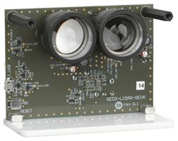
ON Semiconductors has introduced a single point direct Time of Flight (dToF) light detection and ranging (LiDAR) SECO-RANGEFINDER-GEVK Development kit solution that is powered by the Silicon Photomultiplier (SiPM) technology. The SiPM technology used in the device helps provide fast response time and high detection efficiency; this helps to overcome the challenges in traditional photodiodes-based solutions.

Figure3: ON Semiconductor dTOF light detection and ranging development kit
The device is designed with the NIR laser diode, SiPM sensor, optics, and the digital processing necessary to convert the detected signals into elapsed time and subsequently elapsed time into distance. The generated histograms make the device suitable for various applications such as range finding, collision detection, and 3D mapping. The SiPM dToF LiDAR Platform can detect objects at distances between 10 cm and 23 m, and provides out-of-the-box operation with a dedicated GUI.
Given the plethora of benefits, LiDAR technologies and markets continue to evolve fast. LiDAR has proven itself invaluable, and the growth in different areas will make these powerful sensors increasingly available over the coming years. They offer remarkable performance advantages over other technologies and are only a matter of time when LiDAR becomes the go-to sensors for most industries.